Welcome to Rio de Janeiro

Rio de Janeiro: A First-Timer’s Guide to the Marvelous City
You already know the name Copacabana. Maybe from a song, maybe from a vague childhood memory of a World Cup broadcast, maybe just from years of it floating around in the atmosphere of popular culture. It conjures something — heat, music, the idea of a beach so famous it barely seems real. But here is the thing about Copacabana: it is only one street in one neighborhood in one zone of a city so large, so layered, and so alive that most people who visit it for the first time feel like they’ve stumbled into something they weren’t quite prepared for. Rio de Janeiro does that to people. It overwhelms you pleasantly, then pulls you back in before you’ve had time to catch your breath.
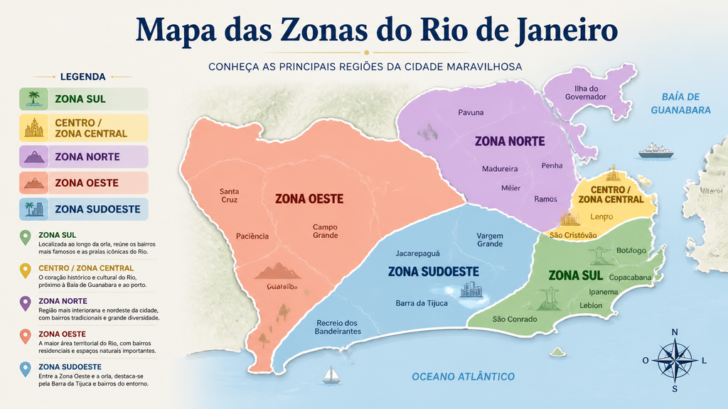
This is a guide for those arriving with little more than that one famous name and an open mind. Rio is not a city you need to decode in advance — part of its charm is that it reveals itself as you move through it. But a little context goes a long way. The city is organized into distinct zones, each with its own personality, history, and rhythm, and understanding how they fit together helps you move through Rio with more confidence and more joy. Think of what follows not as homework, but as an introduction before the real conversation begins.
The City and the Geography That Shaped It
Before zones, before neighborhoods, before any of the human decisions that turned this place into a metropolis of seven million people, there was the landscape — and it is extraordinary. Rio is wedged between mountains and the Atlantic in a way that makes urban planning look like improvisation. Granite peaks rise straight out of the city fabric. A dense forest, the Tijuca, sits inside the urban boundary, larger than many national parks. Lagoons interrupt the neighborhoods. The coastline bends and curves for kilometers, offering one beach after another, each with its own character.
This geography is not just beautiful — it is the reason Rio developed the way it did. Neighborhoods couldn’t simply spread outward in every direction; they had to negotiate with hills and water. Tunnels had to be blasted through rock to connect one valley to another. The city grew in pockets and clusters, which is why even today it can feel like a collection of distinct villages that happen to share a name. Getting from one zone to another sometimes means going through a tunnel, crossing a lagoon by bridge, or climbing a road that winds between peaks. That friction between geography and city is part of what gives Rio its texture.
The result is a place where, within a single afternoon, you can go from standing at the base of a mountain to sitting on a beach to wandering through a historic neighborhood of nineteenth-century churches and tiled buildings. Few cities in the world offer that range so effortlessly.
Centro: Where Rio Began
Every city has a starting point, and Rio’s is Centro — the downtown core that served as the original heart of urban life for centuries. Centro is where the Portuguese colonial administration set up shop, where the port brought goods and people in and out, where the grand civic ambitions of different eras left their mark in stone and tile and iron.
Today, Centro is Rio’s administrative and financial engine. It holds government buildings, courts, banks, museums, and some of the most significant historic architecture in the country. The Arcos da Lapa, a colonial-era aqueduct that now carries a tram line, stands as one of the city’s most recognizable structures — less famous than Christ the Redeemer but, in some ways, more surprising, because it sits in the middle of a neighborhood rather than above it. The surrounding Lapa district is known for its nightlife and its music, particularly chorinho and samba, played in bars and clubs that keep going until the early hours.
The Real Gabinete Português de Leitura, a jaw-dropping nineteenth-century library in the heart of downtown, is the kind of place that stops visitors mid-stride. The Confeitaria Colombo, a Belle Époque café with towering mirrors and stained glass, has been serving coffee and pastries since 1894. Centro rewards slow, curious walking — the kind where you look up at buildings rather than down at your phone. For a first-time visitor, a morning spent wandering from the port area through the historic center to Lapa provides more context for understanding Rio than any amount of reading.
Transit connections in Centro are excellent. Most of the city’s metro lines converge here, and it is the natural hub for moving between zones — which makes it a practical as well as a cultural starting point.
Zona Sul: The Rio of the Postcards (and More)
If Centro is where Rio began, Zona Sul is where it became famous. The South Zone stretches from the hillside neighborhood of Santa Teresa, perched above Lapa, down through Glória, Flamengo, and Botafogo, and then through the tunnel that opened Copacabana to the world in the early twentieth century, and onward through Ipanema and Leblon to the edge of the Tijuca massif. This is the Rio most visitors imagine before they arrive, and it delivers — while also offering more than the postcard version suggests.
Copacabana itself is exactly what it promises: a long arc of beach bordered by a wide mosaic promenade, alive at all hours, populated by everyone from early-morning joggers to late-night revelers. The Copacabana Palace, opened in 1923, still stands as one of the great hotels of South America, its white facade looking out over the water with an air of permanent elegance. The beach is free, public, and democratic in the way that only beaches can be — on any given weekend, you’ll find families, vendors, volleyball games, teenagers, retirees, and tourists from a dozen countries all sharing the same stretch of sand without anyone thinking anything of it.
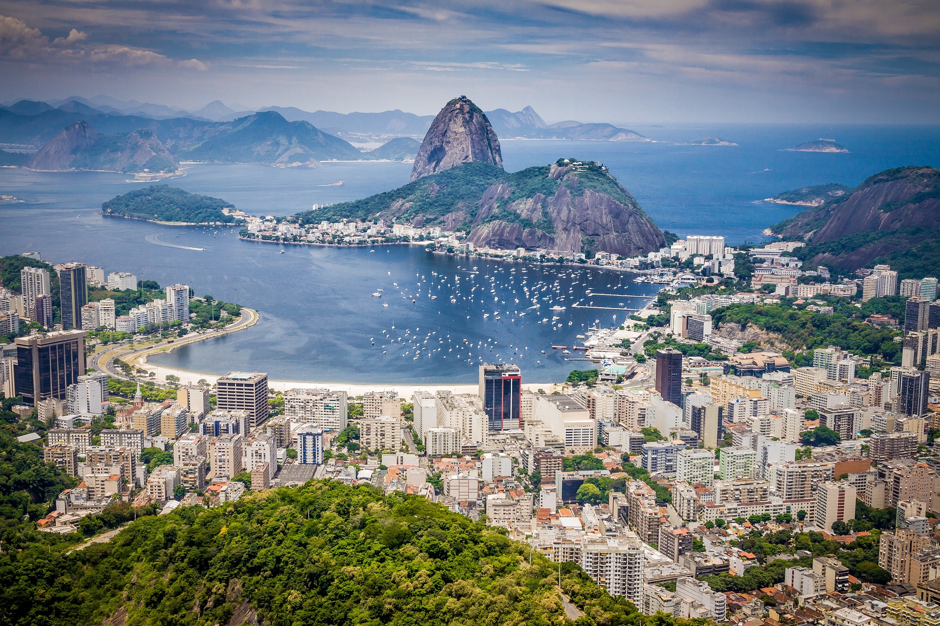
Ipanema, one neighborhood along, has a slightly different energy — a bit younger, a bit more design-conscious, with better restaurants and boutiques tucked into its residential streets. The lagoon behind it, the Rodrigo de Freitas, is ringed by a cycling and jogging path and sits in the shadow of Christ the Redeemer, who looks down from his perch on Corcovado as if keeping an eye on things.
Sugarloaf Mountain — Pão de Açúcar — rises from the edge of Botafogo Bay in one of the world’s most dramatic natural gestures. The cable car ride to the top is not something to skip. The view from the summit, with the city laid out below and the ocean glittering beyond, gives you the spatial understanding of Rio that no map can provide. Go at sunset if you can.
Christ the Redeemer himself, at the peak of Corcovado inside the Tijuca Forest, needs no introduction, but deserves one anyway: the scale of the statue is routinely underestimated by those who have only seen photographs. Standing at the base of it, with the city visible in every direction below, is one of those travel experiences that manages to exceed its own reputation.
Zona Norte: The Heart the City Keeps to Itself
Zona Norte does not appear on most tourist itineraries, and that is a loss. The North Zone is where a large part of Rio actually lives — in dense residential neighborhoods that have been here longer than the famous beaches, shaped by working-class history, by waves of migration, and above all by samba.
Samba did not come from Copacabana. It came from the North Zone, specifically from neighborhoods like Oswaldo Cruz and Estácio, where communities of Afro-Brazilian musicians in the early twentieth century developed what would become one of Brazil’s defining cultural exports. The escolas de samba — samba schools — that compete every year during Carnival are rooted here, in the north. They are not performance troupes for tourists; they are community institutions, with thousands of members from the neighborhood spending the entire year preparing for the few days of Carnival. Visiting one of the larger schools outside of Carnival season, when rehearsals are open to the public, is an experience of a different order than anything Zona Sul offers.
The Sambódromo, the purpose-built avenue where Carnival parades take place, is in Zona Norte. So is Maracanã, the famous stadium that has hosted World Cup finals and Olympic ceremonies, and which on a match day generates an atmosphere that makes other sporting venues feel quiet. Both are worth a visit even outside of their main events.
Zona Norte is also where the city’s transport networks are most concentrated and where daily commerce moves at its most unreconstructed pace. For a visitor willing to step outside the familiar circuit, even a few hours in a North Zone neighborhood offers a more complete picture of what Rio is than any amount of time spent in the postcard zones.
Zona Oeste and Zona Sudoeste: The City’s Expanding West
The western reaches of Rio are less visited and harder to summarize, partly because they cover so much ground — geographically and socially — and partly because they are still becoming what they will eventually be. Zona Oeste, the broad western interior, encompasses neighborhoods like Campo Grande, Bangu, and Realengo: large, predominantly residential, built up over decades of expansion as the city pushed away from the coast and into land that was once agricultural. This is where a significant portion of Rio’s population lives, in a Rio that operates largely outside the tourist economy and on its own terms.
Zona Sudoeste is the newest official zone, recognized in 2025, carved out of what was previously the western classification to acknowledge the distinct character of its neighborhoods. It includes Barra da Tijuca — Rio’s planned, modern district, built on a flat coastal stretch that feels unlike anywhere else in the city, with wide avenues, shopping centers, and a long beach that is cleaner and less crowded than Copacabana. It also includes Recreio dos Bandeirantes, Jacarepaguá, and a string of other neighborhoods that represent some of the fastest residential and commercial growth in the metropolitan area.
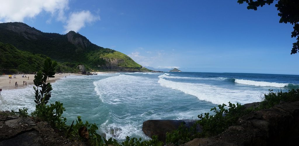
Further west still, accessible by car along winding coastal roads, are beaches like Prainha and Grumari — wild, protected, nearly untouched, tucked inside environmental reserves where development is prohibited. These are the beaches Rio residents drive to on weekends when they want to escape the city without leaving it entirely. The contrast between Grumari’s empty dunes and the packed promenade of Copacabana, both within the same city limits, says something essential about how large and contradictory Rio actually is.
Moving Through the City: A Few Practical Notes
Rio is a large and geographically fragmented city, which means getting around requires some thought. The metro system is clean, reliable, and covers the main tourist corridor well — from Ipanema and Copacabana through Centro and up toward the North Zone. For most of what a first-time visitor will want to see in Zona Sul and Centro, the metro is the simplest option.
Uber and 99 both operate throughout the city and are the most practical way to reach places the metro doesn’t serve, including most of the western beaches and neighborhoods. Traffic in Rio can be serious during peak hours, so build in time accordingly. Walking is wonderful within neighborhoods but less practical between them, given the distances and the heat.
One thing worth knowing: Rio’s heat is real. The equatorial sun in summer — December through March — is intense enough to cause sunburn in under twenty minutes on exposed skin. Hydration, sunscreen, and a hat are not optional equipment. The good news is that brief, hard afternoon rain showers are common in summer; they cool everything down quickly and tend to pass within half an hour.
When to Go, What to Bring, and How to Arrive
The most famous time to visit Rio is Carnival, which falls in February or early March depending on the year. If you go during Carnival, book accommodation months in advance and understand that the city will be operating at a level of intensity it reaches for no other occasion. It is spectacular and exhausting in equal measure, and it is unlike anything else on earth.
Outside of Carnival, Rio is worth visiting year-round. The months from May through September are technically the drier season, with lower humidity, cooler temperatures, and smaller crowds. October and November bring warmth back before the summer rains. December through February is hot, wet, and lively — the city is at its most Brazilian, if that phrase means anything.
Bring light clothing, good walking shoes, a daypack, and a level of attentiveness appropriate to any large city. Rio has a reputation for crime that is not entirely undeserved, but it is also a city of tens of millions of daily interactions, the vast majority of which are unremarkable. Common sense — don’t display expensive equipment, be aware of your surroundings, stick to areas you’ve researched — goes a long way. Ask your hotel or guesthouse staff for current advice specific to the neighborhoods you’re visiting.
The Thing About Rio
Every city has a quality that is finally untranslatable, and Rio’s is something like this: the way its residents — the cariocas — treat ordinary life as something worth savoring. The beach is not a vacation destination for them; it is where you go on a Tuesday evening after work, carrying a towel and a cold can of something in a small insulated bag. The evening air in Ipanema is not a backdrop for special occasions; it is simply Tuesday. The mountains are not scenery — they are the walls of the room you live in.
This attitude is what most visitors feel but struggle to articulate: a sense that Rio operates at a frequency slightly different from other cities, one where pleasure is not deferred and where beauty — in the landscape, in the music, in the way people move through public space — is treated as a baseline condition rather than a luxury. It takes a day or two to calibrate to that frequency. Once you do, going home is harder than it should be.
Come prepared to be surprised. Come prepared to revise whatever you thought you knew. And give yourself more time than you think you need — Rio almost always turns out to be bigger, stranger, and more rewarding than the version of it you arrived with.